Description
The PST uses a three-step process to identify health recommendations for a specific geographic area.
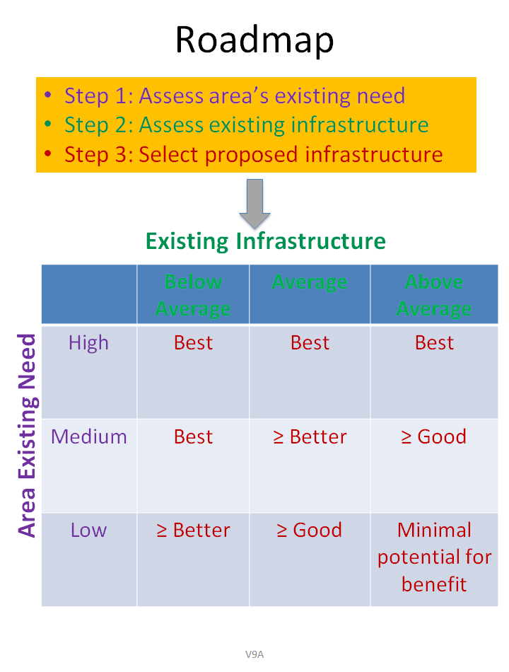
Step 1: Existing Need uses secondary data related to health, equity, active transportation, crashes, land use features, and connectivity to assess an area�s existing needs.
Step 2: Existing Infrastructure uses secondary data and built environment audits to assess an area�s existing walking and biking infrastructure.
In Step 3: Select Propopsed Infrastructure, results from Steps 1 and 2 yield recommendations for how to modify the area to promote walking and biking, including recommendations related to traffic calming, visibility, crosswalks and signalized intersections, bicycle and pedestrian connectivity, asset management, and aesthetics.
In general, the higher an area�s existing need and the less the area is conducive to walking and biking, the more the recommendations aim to promote active transport.
|
|
Using the Tool
Before using this tool, please identify a specific geographic area for a land use project.
Next, complete Steps 1 and 2, which involve gathering information through a series of questions.
Use the information collected through Steps 1 and 2 to select project recommendations in Step 3 that take health into account.
Finally, generate a PDF with the selected recommedations. The PDF can be saved and/or printed out, as necessary.
|
User Tips
Steps 1 and 2 use existing data sources available online. Those are provided by federal government organizations, local municipalities and agencies, and universities.
- Each step contains specific questions about the project area with links to related online resources and detailed instructions on how to use the resource and score the question.
- Many of these websites are easiest to use by inputting a specific address. Select an address within the project area for this purpose. Selecting an address somewhere in the middle of the project area is most helpful, because it improves distance calculations for various amenities.
- If a project encompasses more than one geographic unit of analysis (e.g. Census Tract or block group), answer questions for each involved unit independently. Average the answers to compute final points.
In Step 3, use the scores calculated in Steps 1 and 2 to determine whether the project should be designed and implemented using recommendations that are �good,� �better,� or �best� for promoting health.
This tool recognizes that projects are unique. If choosing not to pursue a particular level of recommendation for a specific item contained in the tool, briefly explain why.
|
Disclaimer
This Project Scoping Tool relies on external sources of information, data, and analysis. The accuracy, recency, and availability of this information, data, and analysis depends on the organizations that maintain them. PST sources should be periodically verified and the PST updated to reflect any changes.
|
Attribution Statement
This project was supported by grant #NU58DP6578, funded by the Centers for Disease Control and Prevention and awarded to the Southern Nevada Health District. Its contents are solely the responsibility of the authors and do not necessarily represent the official views of the Centers for Disease Control and Prevention or the Department of Health and Human Services.
|
Collaboration
This PST was developed through a collaboration between the UNLV School of Public Health, the Southern Nevada Health District, the City of Las Vegas Public Works Department, the Regional Transportation Commission of Southern Nevada, and the Nevada Minority & Health Equity Coalition.
|